सामग्री पर जाएं
TravelHub
चेल्सी, लंदन · यूनाइटेड किंगडम

Oxford Street: आसपास क्या है, कैसे पहुँचें और कब जाएँ · 2026

Long-term residents treat the main thoroughfare as a transit obstacle rather than a shopping strip, routing daily commutes through Marylebone and Soho backstreets to avoid the pedestrian gridlock.

जगहों का मैप
शहर में अभीOxford Street+10°से॰बादल छाए रहेंगे01:08 am पहले अपडेट किया गयाआसपास1
विनिमय दर£0.75प्रति 1 $GBP — देश की मुद्रा3 नव॰ 2026 के अनुसार
मैप लोड हो रहा है
स्थान के बारे में

Oxford Street divides central neighbourhoods while concentrating heavy transit flows along a single retail corridor.

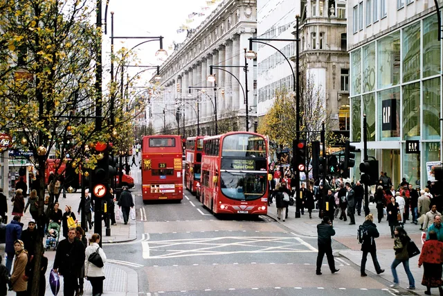
Running between Marble Arch and Tottenham Court Road, the corridor marks the boundary separating Marylebone and Fitzrovia to the north from Mayfair and Soho to the south. Surface traffic along the carriageway is restricted to buses and licensed taxis, making cross-town bus journeys direct while pushing private vehicles onto parallel residential lanes.

आगे पढ़ें

The route originated as a Roman highway connecting ancient settlements and later bore the name of the Tyburn before acquiring its present title. Great landowning holdings, including the Portland, Portman, and Grosvenor estates, shaped the surrounding blocks from former fields into dense commercial developments facing the old coaching road.

Underground connectivity centers on major stations along the Central line, including the junction at Oxford Circus designed by John Nash. Deep rail connections through the Elizabeth line provide dual-ended access points extending toward Hanover Square and Dean Street, allowing commuters to bypass congested platform entrances during peak hours.

संस्थाएं
  • Oxford CircusMajor junction designed by John Nash connecting key Underground lines.
  • Tyburn GallowsHistoric execution site that formerly stood near the Marble Arch junction.
  • Surface Traffic RestrictionsCarriageway access remains restricted exclusively to buses and licensed taxis.
  • Pedestrian CongestionDense crowds make walking the main pavement slow during peak shopping periods.
  • Elizabeth LineCross-rail transit hub with dual access points at Hanover Square and Dean Street.
तथ्य
  • The street follows the ancient course of the Roman highway known as Via Trinobantina.
  • Surface traffic along the corridor is limited to buses and licensed taxis.
  • Architect John Nash designed the circular junction at Oxford Circus.
  • Elizabeth line stations at Bond Street and Tottenham Court Road provide secondary exits into Hanover Square and Dean Street.
  • The thoroughfare serves as the boundary dividing Marylebone and Fitzrovia from Mayfair and Soho.
स्रोत: Wikipedia
तस्वीरों में Oxford Street5 फोटो · 1 स्थान
Taken by Ysangkok · pdm · 1 दिस॰ 2006
Sean Hickin at Flickr · cc-by-2.0 · 1 जून 1974

वहाँ पहुँचना और रुकना

यहाँ अभी कोई मुफ्त आवास प्रदाता (होस्ट) नहीं है — सबसे करीबी शहर जहाँ वे उपलब्ध हैं:

पेरिस5,030 होस्ट · 3 घं॰ 35 मि॰
2 स्रोत · 5 नवंबर 2026 के अनुसार
स्रोत: TravelHub · OurAirports (public domain)

Google समीक्षाएँ

Google Maps पर आगंतुक क्या लिखते हैं

Google Maps की रेटिंग और हाल की समीक्षाएँ माँगने पर लोड होंगी।

Google Maps में खोलें

अपनी पसंद की जगह नहीं मिल रही? खोज टूल किसी भी भाषा को समझता है। खोज खोलें