Мазмұнға өту
TravelHub
Chelsea · Ұлыбритания

Oxford Street: айналада не бар, қалай жетуге болады және қашан бару керек · 2026

Long-term residents treat the main thoroughfare as a transit obstacle rather than a shopping strip, routing daily commutes through Marylebone and Soho backstreets to avoid the pedestrian gridlock.

Орындар картасы
Қалада қазірOxford Street+10°CБұлтты05:36 жаңартылғанАйналада1
Валюта бағамы0,75 £1 $ үшінGBP — ел валютасы2026 ж. 03 қар. күнгі жағдай бойынша
Картаны жүктеу

Айналасында не бар1

Орналасқан жері туралы

Oxford Street divides central neighbourhoods while concentrating heavy transit flows along a single retail corridor.

Running between Marble Arch and Tottenham Court Road, the corridor marks the boundary separating Marylebone and Fitzrovia to the north from Mayfair and Soho to the south. Surface traffic along the carriageway is restricted to buses and licensed taxis, making cross-town bus journeys direct while pushing private vehicles onto parallel residential lanes.

Әрі қарай оқу

The route originated as a Roman highway connecting ancient settlements and later bore the name of the Tyburn before acquiring its present title. Great landowning holdings, including the Portland, Portman, and Grosvenor estates, shaped the surrounding blocks from former fields into dense commercial developments facing the old coaching road.

Underground connectivity centers on major stations along the Central line, including the junction at Oxford Circus designed by John Nash. Deep rail connections through the Elizabeth line provide dual-ended access points extending toward Hanover Square and Dean Street, allowing commuters to bypass congested platform entrances during peak hours.

Қауымдастықтар
  • Oxford CircusMajor junction designed by John Nash connecting key Underground lines.
  • Tyburn GallowsHistoric execution site that formerly stood near the Marble Arch junction.
  • Surface Traffic RestrictionsCarriageway access remains restricted exclusively to buses and licensed taxis.
  • Pedestrian CongestionDense crowds make walking the main pavement slow during peak shopping periods.
  • Elizabeth LineCross-rail transit hub with dual access points at Hanover Square and Dean Street.
Деректер
  • The street follows the ancient course of the Roman highway known as Via Trinobantina.
  • Surface traffic along the corridor is limited to buses and licensed taxis.
  • Architect John Nash designed the circular junction at Oxford Circus.
  • Elizabeth line stations at Bond Street and Tottenham Court Road provide secondary exits into Hanover Square and Dean Street.
  • The thoroughfare serves as the boundary dividing Marylebone and Fitzrovia from Mayfair and Soho.
Дереккөз: Wikipedia
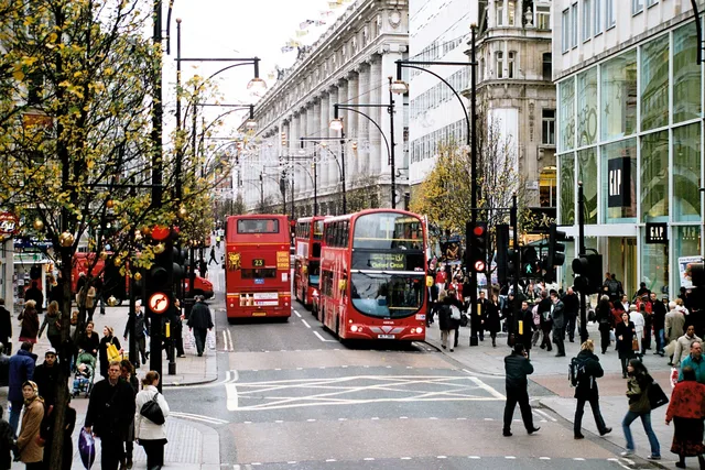
Oxford Street суреттерде5 фотосурет · 1 орын
Taken by Ysangkok · pdm · 2006 ж. 01 жел.
Sean Hickin at Flickr · cc-by-2.0 · 1974 ж. 01 мау.

Жету және орналасу

Бұл жерде әзірге тегін тұруды ұсынатын хосттар жоқ — олар бар ең жақын қала:

Париж5 030 хост · 3 сағ 35 мин
2 дереккөз · 2026 ж. 5 қараша жағдайы бойынша
Дереккөз: TravelHub · OurAirports (public domain)

Google пікірлері

Келушілер Google Maps-те не жазады

Google Maps рейтингі мен соңғы пікірлер сұраныс бойынша жүктеледі.

Google Maps-те ашу