შინაარსზე გადასვლა
TravelHub
ბარსელონა · ესპანეთი

Port of Barcelona: რა არის ირგვლივ, როგორ მივიდეთ და როდის · 2026

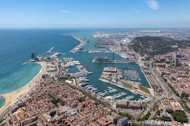
Living beside the waterfront means balancing pedestrian access along Moll de la Fusta against heavy ferry traffic and round-the-clock logistics operations.

Port of Barcelona · CC BY-SA 4.0

ადგილების რუკა
რა არის ირგვლივ3
გაცვლითი კურსი0,89 €1 $-ზეEUR — ქვეყნის ვალუტა3 ნოე. 2026-ის მდგომარეობით
ადგილის შესახებ

Industrial logistics and public waterfront spaces divide the coastline into distinct operating sectors.

The maritime territory separates into distinct operational zones, comprising the historic basin of Port Vell, extensive industrial terminals, and dedicated logistics platforms. State administration oversees daily harbor activities through the central port authority. Urban renewal projects cleared old industrial warehouses and railroad tracks to connect neighbouring Barceloneta directly to the sea.

წაიკითხეთ მეტი

Public access centres on the Moll de la Fusta wharf, while commercial shipping and container handling remain concentrated along southern terminals. A dedicated logistics centre coordinates freight distribution near the municipal boundary. Expanding the outer docks required altering the nearby river channel, creating room for corporate maritime facilities including the World Trade Center complex.

ასოციაციები
  • Port VellPublic waterfront promenade converted from former industrial rail yards.
  • World Trade CenterHarborside business hub hosting international maritime offices.
  • Logistics Activity ZoneMultimodal freight centre managing intermodal freight distribution.
  • Terminal EmissionsHeavy vessel traffic produces noticeable air pollution and engine noise.
ფაქტები
  • The port area is divided into Port Vell, an industrial section, and a logistics zone.
  • The facility operates under the management of the Port Authority of Barcelona.
  • Urban transformation of the northern waterfront began with opening the Moll de la Fusta wharf to public access.
  • Expanding commercial capacity involved shifting the natural mouth of the Llobregat river southward.
წყარო: Wikipedia
Port of Barcelona სურათებში7 ფოტო
NeusCGarcia · cc0 · 16 მაი. 2019
Photograph by Mike Peel ( www.mikepeel.net ). · cc-by-sa-4.0 · 27 ოქტ. 2019

მგზავრობა და განთავსება

უფასო განთავსება მასპინძლებთანმასპინძლების ნახვა
ქალაქში2534მასპინძელი ელოდება სტუმრებს
2 წყარო · 4 ნოემბერი, 2026-ის მონაცემებით
წყარო: TravelHub · OurAirports (public domain)

Google-ის შეფასებები

რას წერენ ვიზიტორები Google Maps-ზე

Google Maps-ის რეიტინგი და ახალი შეფასებები მოთხოვნისას ჩაიტვირთება.

გახსნა Google Maps-ში

ვერ პოულობთ სასურველ ადგილს? საძიებო სისტემას ნებისმიერი ენის ესმის. ძიების გახსნა