





Անցնել բովանդակությանը
TravelHub
Փիթսբուրգ · Ամերիկայի Միացյալ Նահանգներ

Fort Duquesne: ինչ կա շուրջը, ինչպես հասնել և երբ գնալ · 2026

Downtown residents treat the park grounds as an everyday jogging corridor, dodging crowds that gather along the granite outlines between the riverfront trails.

Վայրերի քարտեզ
Այժմ քաղաքումFort Duquesneտեղական ժամանակը տեղումԻնչ կա շուրջը6
Փոխարժեք1,00 $1 $-ի դիմացUSD — երկրի արժույթը03 նոյ, 2026 թ. դրությամբ
Քարտեզի բեռնում
Վայրի մասին

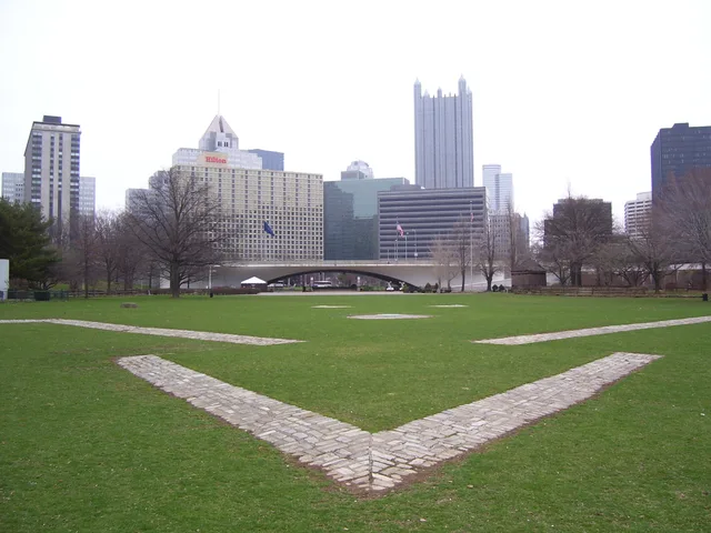
Granite outlines mark where colonial powers fought to control the river gateway.

French troops erected Fort Duquesne after dismantling an English trading post at the forks of the rivers to secure the Ohio Valley. Designed on the plan of Fort Frontenac, the wooden stronghold anchored French claims linking Quebec with Louisiana. The outpost triggered military clashes with Virginian militia led by George Washington, marking the outbreak of the French and Indian War across the frontier.

Կարդալ ավելին

Holding the forks proved difficult because the riverbank suffered from marshy ground and frequent flooding. Surrounding river bluffs exposed the garrison to artillery bombardment from the higher shore. When British forces advanced, the defenders destroyed the fort rather than surrender it. Point State Park preserves the site today, using stone markers set into the lawns to show where the defensive walls once stood.

Ասոցիացիաներ
  • Point State ParkGranite stones embedded in the lawn outline the old ramparts.
  • Forks of the OhioThe confluence formed a vital transport junction for colonial trade.
  • French and Indian WarSkirmishes near the outpost sparked the wider Seven Years' War.
  • Flood-Prone TerrainLow riverbanks and nearby bluffs left the garrison exposed to floods.
  • George WashingtonEarly military missions here helped shape his colonial command.
Փաստեր
  • French forces destroyed the garrison before British troops arrived to capture the position.
  • The outpost was modeled on the layout of Fort Frontenac in New France.
  • Granite stones in Point State Park trace the footprint of the original fortifications.
  • High ridges across the river made the low-lying wooden fort vulnerable to bombardment.
Աղբյուր՝ Wikipedia
Fort Duquesne նկարներում7 լուսանկար · 1 վայր
Kevin Myers at English Wikipedia · cc-by-sa-3.0 · 20 մյս, 2006 թ.
Unknown author Unknown author · pdm
MartinThoma · cc0 · 07 հնս, 2014 թ.
Fort Duquesne
James Mitchell from Philadelphia, United States · cc-by-sa-2.0 · 24 հնս, 2008 թ.

Ինչպես հասնել և որտեղ մնալ

2 աղբյուր · Առ 04 նոյեմբերի, 2026 թ.
Աղբյուր՝ TravelHub · OurAirports (public domain)

Google-ի կարծիքներ

Ինչ են գրում այցելուները Google Maps-ում

Google Maps-ի վարկանիշն ու թարմ կարծիքները կբեռնվեն ըստ պահանջի։

Բացել Google Maps-ում