
- Distancia
- 10 km
Burlington · Estados Unidos
Lago Champlain: qué hay cerca, cómo llegar y cuándo ir · 2026
Living beside the lake means building daily transit around ferry slips and waterfront paths rather than continuous highways across the water.
Qué hay cerca3
Tipo de cambio1,00 $a fecha de 2 nov 2026
Sobre el lugar
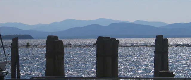
Lake Champlain defines the border between states and nations while structuring regional water transport.
Lake Champlain forms a major freshwater passage between Vermont, New York, and Quebec. Indigenous Abenaki and Mohawk nations treated this corridor as a strategic frontier long before European arrival. Abenaki records name it Pitawbagok, while Mohawk records describe it as a gateway territory. The waterway remains a working transit route.
Seguir leyendo
Colonial campaigns relied on the lake to move artillery and troops between river valleys. Continental forces captured Fort Ticonderoga and Crown Point to secure heavy cannons and clear water access heading north. Modern harbors at Burlington and Plattsburgh now prioritize ferry services, recreational boating, and seasonal passenger vessels.
Asociaciones
- Fort Ticonderoga
- Burlington harbor
- Waterway border crossing
Datos
- The freshwater body spans across parts of Vermont, New York, and Quebec.
- Abenaki and Mohawk nations established ancestral border territories across the water basin.
- Colonial armies captured Crown Point and Fort Ticonderoga to control the corridor toward Canada.
Lago Champlain en imágenes8 fotos
Cómo llegar y dónde quedarse
2 fuentes · A fecha de 3 de noviembre de 2026
Fuente: TravelHub · OurAirports (public domain)
Lugares cercanos similares
- Distancia
- 11 km
 Aeropuerto Internacional de Burlington
- Distancia
- 15 km
Ciudades de Estados Unidos
Lugares en Lago Champlain
Países cercanos
Preguntas frecuentes sobre Lago Champlain
¿No encuentras el lugar que necesitas? La búsqueda entiende cualquier idioma. Abrir búsqueda