Aller au contenu principal
TravelHub
Bnei Brak · Israël

parc Ariel-Sharon: ce qu’il y a autour, comment y aller et quand venir · 2026

Residents settling near the rehabilitated mound trade dense metropolitan streets for expansive green trails, while navigating constant flight paths overhead.

À propos du lieu
À propos du lieu

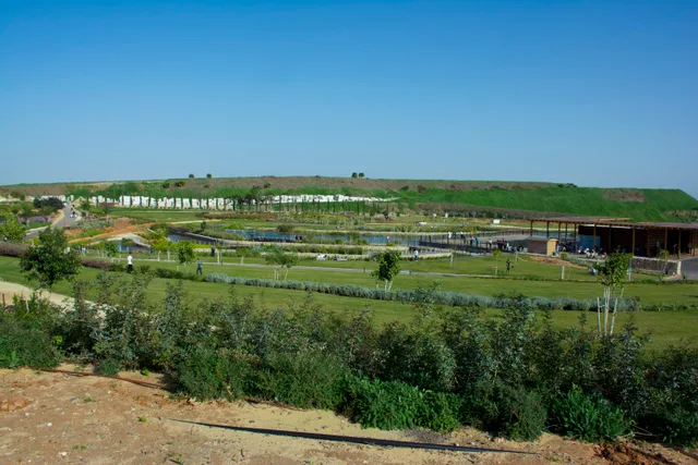
A massive former waste mound anchors an ambitious regional green lung southeast of the main metropolis.

Ariel Sharon Park transforms a massive historical waste dump into an expansive ecological park. The vast territory sits along the Ayalon River corridor between the primary airport and the central highway. The surrounding boundaries incorporate Menachem Begin Park, the agricultural village of Mikveh Israel, and the historical Shalem Farm into a unified open space that continues ongoing development.

Lire la suite

The elevated hill once accumulated immense urban waste, causing severe groundwater contamination, noxious gas emissions, and flock hazards for approaching aircraft. Following public health protests and aviation safety concerns, dumping ceased entirely. The Dan Region Association of Towns manages the grounds, operating specialized facilities at the base that process green mulch, building materials, and sorted refuse.

Associations
  • Hiriya LandfillThe former waste mound was transformed into an ecological park.
  • Aviation Bird StrikesGarbage once drew large bird flocks that threatened airport traffic.
  • Ayalon River BasinRiver plains provide regional drainage and vital green corridor space.
  • Recycling InfrastructureBase plants process sorted waste, building rubble, and green mulch.
Faits
  • The park occupies a reclaimed waste mound southeast of Tel Aviv along the Ayalon River corridor.
  • Decomposing refuse once attracted massive bird flocks that created safety hazards for aircraft at Ben Gurion Airport.
  • Specialized recycling plants at the foot of the hill process sorted waste, mulch, and construction debris.
  • The site operates outside municipal boundaries under the Dan Region Association of Towns.
Source : Wikipedia
parc Ariel-Sharon en images8 photos
MathKnight · cc-by-4.0 · 13 déc. 2014
StateofIsrael · cc-by-sa-2.0 · 16 sept. 2011
Avi1111 dr. avishai teicher · cc-by-sa-4.0 · 18 mai 2019

Arriver et se loger

2 sources · Au 4 novembre 2026
Source : TravelHub · OurAirports (public domain)

Avis Google

Ce que les visiteurs écrivent sur Google Maps

La note et les avis récents de Google Maps se chargent à la demande.

Ouvrir dans Google Maps